


GeoHazards 2024, 5(2), 504-529; https://doi.org/10.3390/geohazards5020026 - 1 Jun 2024
Abstract
The catastrophic failure of two dams in Libya on 10 and 11 September 2023 resulted in the devastating flooding of the city of Derna, which is located downstream of the dams, causing more than 6000 fatalities and displacing thousands of residents. The failure
[...] Read more.
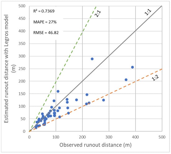
The catastrophic failure of two dams in Libya on 10 and 11 September 2023 resulted in the devastating flooding of the city of Derna, which is located downstream of the dams, causing more than 6000 fatalities and displacing thousands of residents. The failure was attributed to heavy rainfall from Storm Daniel, leading to the dams reaching full capacity and subsequently overflowing and failing. This paper presents an analysis of the dam break, including the modelling of flow discharge and the resulting flooding of Derna. For validation purposes, this study compares the modelled quantities with post-event satellite imagery from UNOSAT and Copernicus, local reports, and data collected from social media using AI detection. The findings provide valuable insights into the dynamics of the dam break and its initial parameters, as well as an assessment of the accuracy of the results. The analysis is performed using a rapid estimation technique developed by JRC to provide the international emergency community with a swift overview of the impact and damage assessment of potential or actual dam break events. The use of all available data shows a satisfactory comparison with the calculated quantities. The rapid modelling of dam break events and combined analysis of multiple data types are proven suitable for promptly assessing the expected dynamic of the event, as well as reconstructing the unknown initial conditions before the break. Incorporating sensitivity analyses provides an estimate of the uncertainties associated with the deduced values of the unknown parameters and their relative importance in the analysis.
Full article
(This article belongs to the Topic Geotechnics for Hazard Mitigation)


